Landform Survey and Design (Australia) provides sales and technical support services for the LevelGuide GPS controlled land levelling system.
LevelGuide system at a glance
- Easily create single plane or multiple plane designs
- Easily create contour banks
- Record terrain heights
- Show areas covered
- Mark runlines for visual and autosteer guidance
- Mark special features
- Multiple farm field and job record keeping
- Technical support and product backup
Screen display information [click images to enlarge]
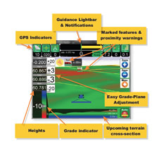
LevelGuide’s front screen shows all relevant information in one straightforward format, including:
- 3D perspective mapping
- Cut-fill colouring
- Plane outlines
- Over/under grade indicator
- Upcoming terrain cross-section
- Target and Blade and Original height indicators
- Easy plane setup and adjustment
A LevelGuide design can be created using four techniques
- Triple reference points (just mark 3 points then start working – it’s that easy!)
- Dual reference points, with designed cross-fall
- Single reference point, with designed main-fall and cross-fall
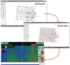
- Full multi-plane design using separate EziGrade software to generate a comprehensive cut-fill map
- LevelGuide can also be used to mark a rising or falling contour bank by marking a reference point and defining a slope


